2.3 Developing the Questionnaire
SAC/IMSMA Version
The Information Management System for Mine Action
(IMSMA) was built to house data collected through the use of the Survey Action Centre's (SAC Protocol 13 - Questionnaire). Though it was originally anticipated that the SAC questionnaire would be used during the Cambodia survey, preliminary review by survey staff with in-country experience and initial comments from the Cambodian mine action community at large indicated that the SAC questionnaire would not meet all of Cambodia's information needs with respect to the mines problem. Furthermore its complexity and length were widely viewed as obstacles to implementing a sound survey in Cambodia for a variety of reasons:
- Not all questions were relevant in light of the generally rudimentary stage of socio-economic development in Cambodian villages;
- In light of the degree of 'survey fatigue' in Cambodia it was felt that people would not take the survey seriously or afford it the time necessary to produce a good result – this problem would be exacerbated if a great deal of time was taken to gather 'incidental' data at the village level.
There had also been a coordinated effort recently put into developing the CMAC Level One Survey Questionnaire by the mine action community. This instrument was seen as being of a reasonable length; collecting data specifically relevant to the information needs of Cambodia; and formatted in such a way that both surveyors and villagers would understand the questions.
As a result of GeoSpatial's consultations with the mine action community it was decided that the questionnaire must:
- be specifically tailored to suit local conditions and realities and to be reflective of the situation in which Cambodian villagers find themselves;
- report on the full range of
contamination that villages actually experience and suffer from in their daily lives (beyond a sole focus on mines);
- be able to be implemented by surveyors that generally have less than a high school education. Simplicity of design and clarity of content are essential in order to maximize understanding by the people who will be implementing it;
- be clearly understandable by Cambodian rural villagers and presented in culturally acceptable language;
- be able to be implemented at an average rate of one village per day (the survey may be completed in several villages if they are not contaminated but it may take several days to complete the survey in heavily contaminated villages).
The Revised Questionnaire
Development of the CMAC questionnaire had been funded by the European Commission. The EC generously contracted the services of one of the consultants who produced the CMAC questionnaire to work with the GeoSpatial L1S team to ensure that the lessons learned during that process were brought forward. Attention focused on why the CMAC questionnaire included questions that were not in the SAC questionnaire; and why some of the questions included in the SAC questionnaire were not included in the CMAC questionnaire. This enabled the drafting of a new questionnaire that eliminated questions included in the SAC questionnaire that were perceived as irrelevant or with little value in the Cambodian context, and that included questions from the CMAC questionnaire that were not in the SAC questionnaire. An effort was made to ask questions in as simple and straightforward a manner as possible toward easing translation difficulties and ensuring understanding.
This draft was circulated throughout the mine action community for comment and underwent a number of revisions before being 'finalised' for use during surveyor basic training.
Areas where translation proved difficult and where surveyors' understanding of the meaning and intent of a question was problematic became apparent during the training phase of operations. In all instances, efforts were made to achieve clarity and to elicit surveyor suggestions for improvement. The recommendations made by the surveyors formed the basis of a new version of the questionnaire. The new version aimed to elicit the same information as the previous version but is significantly different in that it was first drafted in Khmer and only later translated into English. The practical components of the surveyors' training course allowed the new version to be tested at the village level in advance of a more formal 'pre-test' prior to commencement of actual survey operations.
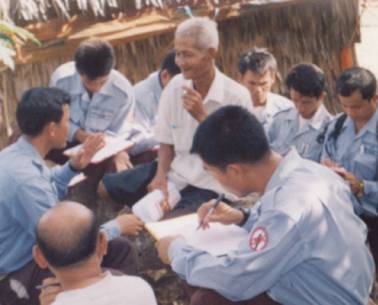
Trainees practice administering the questionnaire
to a villager in Kompong Chhnang Province
Questionnaire Pre-Test
The more formal pre-test of the questionnaire took place August 1–4, 2000 following the completion of the basic surveyor training course and the final selection of surveyors. Teams were deployed to various villages in Kompong Chhnang Province and implemented the entire questionnaire as it was to be administered during normal survey operations. On August 5, teams gathered to participate in a workshop aimed at identifying any lingering areas of confusion, ambiguity and error. 'Final' changes were made to the questionnaire as a result of the discussions that took place at the workshop.
See the questionnaire.
Questionnaire Evolution in the Field
On 25 August 2000, after three weeks of survey operations, survey teams again gathered to discuss the questionnaire and procedures for survey implementation. Rather than requiring additional changes to the questionnaire, identified problems were able to be addressed by amending survey SOPs. In particular, surveyors highlighted difficulties in coordinating meetings with village chiefs and other local authorities that were often not available when the surveyors arrived. In this case procedures were amended such that an advance delegation visited villages and arranged appointments with the necessary respondents several days in advance of the actual survey. Other issues included how to deal with situations where a GPS reading could not be taken inside a village because the village is in a suspected mined area, and surveyor uncertainty as to when a suspected area should not be sketched due to its distance from the village and/or unclear access. As a result, survey procedures related to gathering information on suspected areas were expanded and clarified to ensure surveyor safety. Three significant sets of survey data were changed during the course of the survey in response to feedback from surveyors and potential users of the survey. They were:
1. Victim Information
Originally it was thought that detailed nation-wide information collected by the Cambodian Mine Victim Information System (CMVIS) would eliminate the need for the Level One Survey to collect victim-related information. It was decided in consultation with UNMAS that data could be used if the data was verified by Level One Survey teams. Thus during the early stages of survey implementation in Kampong Chhnang, Pursat and Battambang Provinces, surveyors were provided with copies of CRC data and instructed to attempt to verify the victim's name and the location of his or her accident. Over the duration of the survey four different approaches were taken to the collection of victim information. These are detailed in section 7.3 Cambodia Mine Victim Information System.
2. UXO Reports
Survey Action Center (SAC) Protocols indicate that Level One General Surveys are to collect information on both mine and UXO contaminated areas (SAC Protocol 1 - 31/03/00). A slightly modified version of the existing UXO form in use by CMAC was used without further modification throughout the entire survey process.
These reports were scanned but not entered into database.
3. Cluster Bombed Areas
Cluster bombs are a particular class of UXO that while not technically mines may impact on communities in a similar manner. Although not identified as presenting problems during the pre-test or in provinces that were surveyed in the early month of the project, in heavily-bombed Kompong Thom surveyors quickly became bogged down reporting on high numbers of cluster bomb contaminated areas. The survey questionnaire was again modified to take into consideration this new process was experience of the Cambodia National Level One Survey in dealing with the issue of cluster bombs is as follows: Initially, survey documentation recorded a distinction between:
- Contaminated areas (minefields; cluster bombed areas and heavily UXO-contaminated areas requiring systematic clearance)
- Spot UXO (one or several explosive items requiring an EOD response).
Though this level of distinction was adequate in the initial stages of the survey, as the teams moved into areas that had suffered severe aerial bombardment during the Vietnam war, they quickly became bogged down reporting on a large number of cluster bombed areas.
See section 7.4 - Aerial Bombing.
Many of these cluster bomb contaminated areas however were reported to not have any socio-economic impact on nearby communities. This was largely because the contamination was in areas of low population density where pressures for land are less immediate
, or because the bomblets had already been removed from the surface by villagers
.
It was clear that collecting detailed information on all areas contaminated by unexploded cluster bomblets would put the project significantly behind schedule
. The decision to add an additional level of distinction amongst types of contamination was made as follows:
- Areas of actual or suspected cluster bomb contamination causing adverse socio-economic impact in a community would be comprehensively reported in the same manner as suspected mined areas.
- Areas of actual or suspected cluster bomb contamination that were not currently causing an adverse socio-economic impact in a community would be reported on in a similar manner to spot UXO.
This approach ensured that currently non-impacting cluster bombed areas would be identified for further consideration in response to demographic change or the implementation of engineering projects such as irrigation canals and road construction
.